
The site has just been updated: reload the page to get everything working again.
Plateau d'Emparis
France · Provence-Alpes-Côte d'Azur
Overview
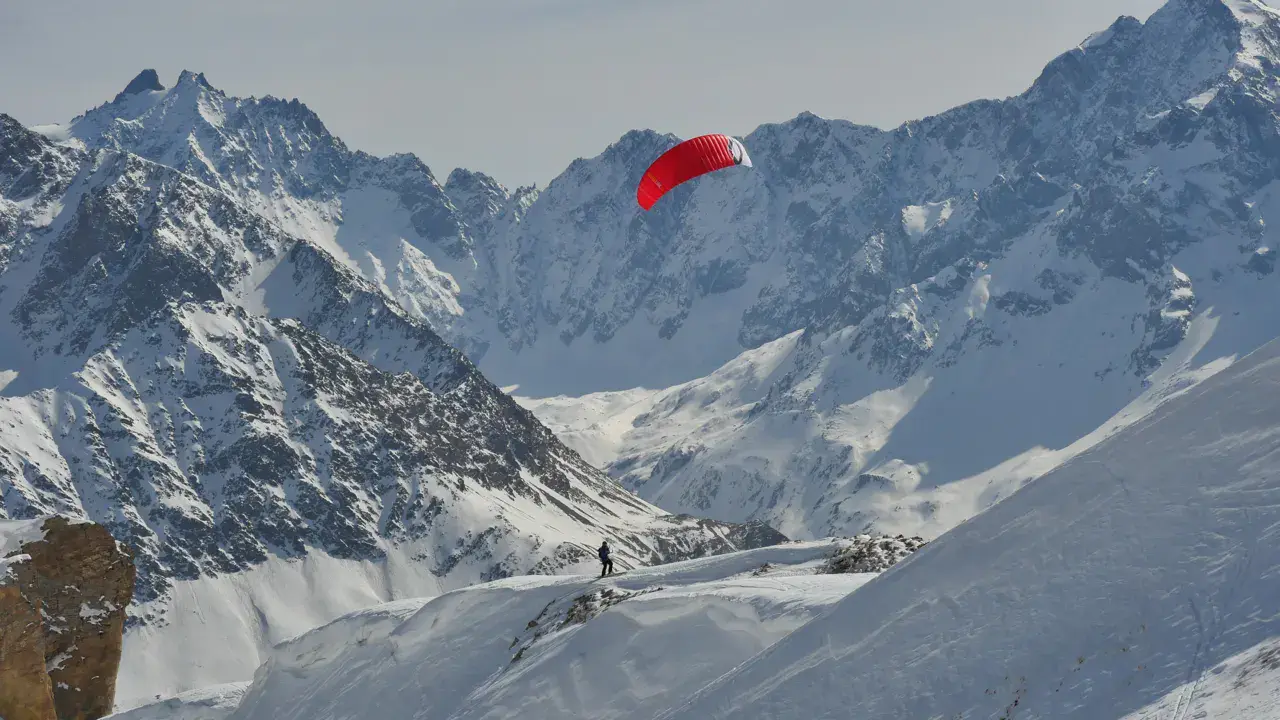
The Emparis plateau is one of the most beautiful and largest snowkite spots in France, perched above La Grave in the Hautes-Alpes. Breathtaking views of the north face of La Meije (3,983 m) and Le Râteau. Altitude between 2,000 m and 2,535 m (Petit Têt).
The terrain is vast and varied: domes, ridges, hollows, small cols, sustained slopes and powder bowls. Wind is generally strong on the domes and ridges, more erratic in the valleys, making riding technical but extraordinarily fun.
Easy access via the Chazelet ski lift (station above La Grave). Ideal backup spot when wind is too strong at Col du Lautaret. Several sub-spots: ridges above the lift, Serre Bernard (2,363 m), Petit Têt (2,535 m), Col du Souchet (2,360 m), and the true Emparis plateau beyond.
Spot forecast for Plateau d'Emparis
Sunrise 07:57 · Sunset 18:42
Forecasts provided by Open-Meteo
Plateau d'Emparis: when to go?
Rideable days and hours computed for a minimum wind of 7 knots · log in to set your own (foil, twin-tip…)
186h
in July · 26 rideable days
The season runs from April to September, peaking in July: 22 rideable days a month and 186 hours of usable wind, at 10 °C. The low point is November, at 11 days.
Rideable days per month
Wind strength when it is rideable
When the spot works, wind sits mostly between 7 and 12 knots — 78% of rideable hours. Big-kite territory. The coldest month is January, at -2 °C. The wettest month is January, with 230 mm. Snow depth peaks in January, at 118 cm.
Monthly averages: Plateau d'Emparis
| Month | Rideable days | Usable wind | Temperature | Rain |
|---|---|---|---|---|
| January | 14.5 | 126 h | -2 °C | 230 mm |
| February | 12.5 | 93 h | -1 °C | 64 mm |
| March | 17.5 | 148 h | 0 °C | 98 mm |
| April | 19.5 | 166 h | 3 °C | 95 mm |
| May | 20.0 | 128 h | 6 °C | 101 mm |
| June | 23.5 | 201 h | 14 °C | 135 mm |
| July | 26.0 | 186 h | 14 °C | 86 mm |
| August | 22.0 | 127 h | 16 °C | 111 mm |
| September | 19.5 | 137 h | 9 °C | 149 mm |
| October | 16.0 | 113 h | 6 °C | 182 mm |
| November | 11.0 | 69 h | 1 °C | 151 mm |
| December | 13.0 | 103 h | -1 °C | 113 mm |
Photo gallery of Plateau d'Emparis
Ridden here? One photo or video, and the spot comes alive for everyone discovering it.
Technical details of Plateau d'Emparis spot
The spot works with winds from NNE, NE, ENE, E, ESE, SE, W, WNW, NW, NNW.
Local association recommendations
Onekite – Isère-based kitesurfing, snowkite and powerkite association. Many session reports from Emparis on the forum.
FFVL – French Free Flight Federation
Spot functioning
Standard access via the Plateau d'Emparis ski lift from Chazelet station (above La Grave). At the lift summit (~2,100 m), wind is immediately felt.
Several levels of exploration:
Chazelet ridges: accessible straight from the lift, ideal for first discovery.
Serre Bernard (2,363 m) and Petit Têt (2,535 m): kite-powered ascent in east wind, playful slopes and powder bowls.
Col du Souchet (2,360 m): gateway to the true Emparis plateau. Trickier in north wind.
Grand Emparis tour: serious commitment, plan a full day, reconnoitre terrain beforehand.
Spot opening date
- Spot opening date
- Open all year round
- Spot type
- Freeride (Ski touring access)
- Altitude
- 2,444 m
Parking
From Grenoble, head towards Col du Lautaret then La Grave. Drive up to Le Chazelet village (above La Grave). Park at the Chazelet station.
Take the Plateau d'Emparis ski lift to the top (~2,100 m). Touring ticket: approx. €5 per ride. You can check wind conditions from Villard d'Arène with binoculars — a large windsock is visible at the lift summit.
Alternative access from Besse-en-Oisans (600-800 m elevation gain on touring skins).
Wind specificities
Emparis works best in east and north-east wind — the prime orientation. Expect at least 25 knots forecast E/SE to be sure. Emparis is the best backup when Lautaret is too windy for the 3 Évêchés.
East / North-East wind: riding in all directions, full exploitation of the spot. 20-30 knots on ridges and venturi effects at small cols, calmer in hollows.
North-West: works in the ascent section (ridges above the lift).
West and South: theoretically rideable but La Meije directly opposite may block some south orientations.
Wind is strong on domes and erratic in valleys. Complex patterns: wind can shift direction depending on your location on the plateau.
Hazards
Serious alpine mountain spot requiring experience and humility. Mountain snowkiting is a true mountaineering discipline.
Avalanches: despite the name "plateau", there are many steep slopes below ridges and in bowls. Significant wind slab risk in easterly flow. Beacon/shovel/probe mandatory. Check avalanche bulletin before every outing.
Wind holes: the rolling terrain creates wind-dead zones in hollows. You can get stuck far from the lift and have to walk a very long time to find wind again.
Remoteness: beyond Col du Souchet, this is one of the most remote areas in France. Bring compass, GPS, generous time margin, and touring skins.
Complex wind patterns: wind direction changes across different zones of the plateau. Reconnoitre the terrain over several sessions before committing to the grand tour.
Something out of date? Suggest an edit
Live
Alpe d'Huez 270012.7 kmsource FFVL
Readings reserved for Premium members
Readings from Alpe d'Huez 2700 weather station are reserved for Premium members.
- Real-time readings
- Last 48 hours history
- Custom alerts
- Extended weather forecasts
Already a Premium member? Log in
Additional stations
-
Décollage 2700m12.7 km
Readings reserved for Premium members
source Pioupiou
-
ALPE-D'HUEZ12 km
Readings reserved for Premium members
source meteofrance
All the details of your session on windtracker.app
Webcams near Plateau d'Emparis
Webcams provided by Windy.com
Schools, shops and places to stay nearby
Directory: France
Nearby spots
All spots: Provence-Alpes-Côte d'Azur- 13 km Col du Lac BlancAuvergne-Rhône-Alpes, France
- 14 km Col du LautaretProvence-Alpes-Côte d'Azur, France
- 18 km Col du SabotAuvergne-Rhône-Alpes, France
- 28 km Serre ChevalierProvence-Alpes-Côte d'Azur, France
- 35 km Lac de LaffreyAuvergne-Rhône-Alpes, France
- 40 km Le ConnestAuvergne-Rhône-Alpes, France
Comments 0
No comments yet.